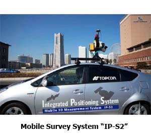
Topcon Releases IP-S2 Series Mobile Surveying and Mapping Systems in Japan and Asia
Topcon Corporation releases the IP-S2 and the IP-S2 Lite*, vehicle-mounted surveying and mapping systems, in Japanese and Asian markets for GIS applications.
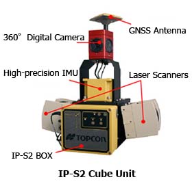
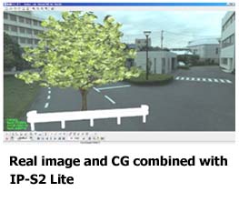
The IP-S2, mobile survey system, incorporates state-of-the-art sensing technologies, including high-precision GNSS receivers, IMU (inertial measurement unit), vehicle wheel encoders, 360° digital video camera and laser scanners. The IP-S2 Lite, mobile mapping system, is an affordable alternative that uses GPS/IMU-combined unit for position detection and 360° digital video camera for spherical image capture.
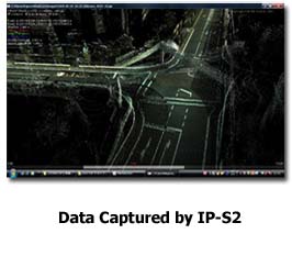
While driving the system-mounted vehicle at normal traffic speeds, the both systems simultaneously collect precise vehicle position/bearing data and capture spherical imagery of roadside objects such as sidewalks, buildings, tunnels, bridges and overpasses. In addition, the IP-S2 acquires high-resolution point cloud data of objects using laser scanners that make more precise analysis possible.
Geographic Information System (GIS) using digital maps and databases is becoming an essential infrastructure of today’s society. Creating or updating digital maps/databases requires huge volume of 3D spatial data. Collecting such data with conventional methods, using diverse kinds of surveying instruments and a number of operators, takes considerable time, labor and cost.
With the IP-S2 series, a single crew with a single vehicle can acquire complete dataset while driving, providing revolutionary solution for 3D data collection. Time-stamped, geo-referenced spatial data or imagery allow users to easily identify features, assign attributes, and export them to users’ applications. Additionally, the IP-S2 series significantly increases safety by eliminating the risk of working in busy streets and highways.
Applications of GIS technology are rapidly increasing, which include urban planning, land-use planning, disaster prevention, public security, traffic safety, environmental preservation and a variety of information services for citizens and travelers.
Topcon IP-S2 and IP-S2 Lite offer high-speed, cost-effective 3D spatial data collection solutions with unparalleled safety for emerging GIS businesses.
* The IP-S2 was first launched in North America in July, 2009. The IP-S2 Lite is initially marketed in Japan and Asia.