

‘We can reduce labor volume from a normal three or four days at the site to only a day included the post-processing work in the office.’
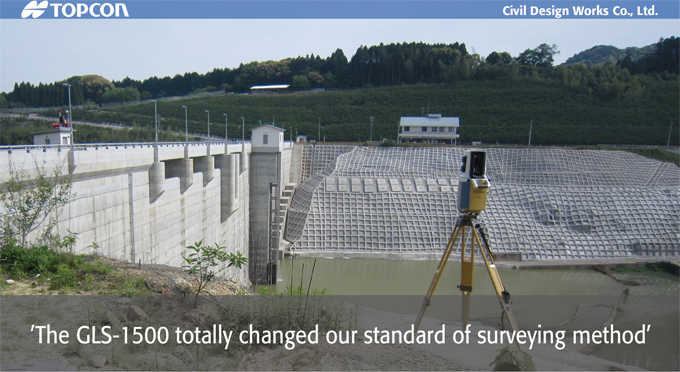
Civil Design Works Company Limited (Kumamoto Prefecture, Japan) is the civil engineering consultant firm that specializes in surveying and construction design projects as well as standard geological survey jobs. In addition to major roadway and other infrastructure projects, the company recently used a TopconGLS-1500 3D laser scanner for periodic monitoring and slope measurement of Ideguchigawa dam, Saga Prefecture.
Kenji Mizumoto, company representative director, said, “Since we started using the field scan function of robotic total station for 3D measuring work a few years ago, we were looking for an instrument which can achieve precise accuracy faster to get more dense point cloud result. After much evaluation of competing products, we purchased the GLS-1500 after analyzing its specifications and return on investment factor.”
To test the accuracy of GlS-1500 Mizumoto surveyed a cross-section shape with it and compared with the one measured by a total station. He admitted to being “very surprised to get the same results.” He said, “The GLS-1500 totally changed our standard of surveying method. By the traditional method, we had to decide in advance which sections to survey. But with the GLS-1500, we scan the whole site, and then extract section data necessary for design consideration. “We changed the way we survey due to the capabilities of the GLS-1500; now we scan the entire site, not just some sections. With the data from the entire site, we determine the work process by looking at the re-created site model in the office.” He said, “The GLS-1500 will not be for just special projects. We will use the instrument on every job, just as we would with other surveying instruments at any job site.”
Tomoyuki Urakawa, company director, said, “We used to take some pictures to figure out the best way to proceed on worksites, but there were no measurements on those pictures. With GLS-1500, we are able to instantly see the site and determine any special circumstances together with dimensional data. Once we have scanned the whole site, if we detect any irregularities at the site, we can deal with it without going to the site again. The GLS-1500 stores complete site information, as if we use a camera to make a picture.”
How efficient is the GLS-1500? He said, “We can reduce labor volume for cross-section survey at the site from a normal three or four days at the site to only a day and that includes the post-processing work in the office. At the site we remotely control the GLS-1500 through a computer inside the car connected via WLAN (wireless) network.” He said an important side feature of the GLS-1500 is that with the remote measurement capabilities of the instrument, site measurement can be done safely.”
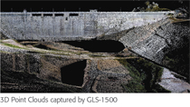
Mizumoto also said, “We provide the 3D data together with other general deliverables to our customers in order to differentiate from competitors. It’s a big advantage t3D Point Clouds captured by GLS-1500o be able to add new values to our measured result without any extra work. Our experience is that the results can be quickly evaluated and are highly appreciated by our clients. It’s a big advantage to our company to be able to provide the 3D data so that the project contractor can put it in their design proposal. We plan to utilize the GLS-1500 in any jobs.” he said, and they are constantly looking for way to more widely apply the 3D laser scanning technologies on every project.


COMPANY:Civil Design Works Co., Ltd.
TOPCON PRODUCT:
3D Laser Scanner GLS-1500