

Vast amount of data captured by Topcon’s IP-S2 Lite mobile mapping system dramatically increases efficiency in inspection of road surfaces over long distances.
In Miyagi prefecture where buildings and houses were virtually destroyed and thousands of other structures were mangled due to the March 2011 magnitude 9.0 mega-earthquake and ensuing tsunami, the required repairs to this country’s infrastructure never seems to end.
The country’s infrastructure development – in addition to the rapid development of commercial and residential buildings — should have been proceeded rapidly and consistently.
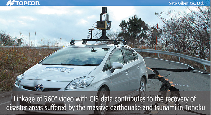
Sato Giken Co., Ltd. is a construction consulting company based in Miyagi; the company specializes in surveying and design works in the Tohoku area. The company used Topcon’s mobile mapping system IP-S2 Lite for the assessment of damages to help project which determines what recovery efforts from the disaster would be needed. The assessment survey work is extremely important to assist in determining the proper recovery methods and to help setting operational plans based on the degrees of damages.
“The amount and scope of damages were much greater than originally anticipated,” said Kazuya Kato, general manager of Geospatial Information Division of the Sato Giken, “The problem was conducting an assessment survey in such a wide area in a limited period of time by conventional surveying method combined with enormous number of recording photographs.”
Executives at Sato Giken, which introduced the IP-S2 Lite system to the company three years ago, saw this job as a good opportunity to utilize the advantage of IP-S2 Lite for the assessment work. Topcon’s IP-S2 Lite is a mobile mapping system integrating 360° video camera, GPS and IMU that allows capturing geospatial data of road surface and peripherals while driving the vehicle equipped with the system.
Kato continued, “We were able to perform the assessment work of roads over long distances. This system played a great role toward the objective of completing the assessment phase of the project quickly.”
“Our company employees undertook the assessment work for 22 routes, including prefectural routes totaling about 237km.” Kato explained the efficiency of the system by saying, “In the conventional method for 10km assessment, as an example, we placed seven staff and usually took three days. However, with the IP-S2 Lite system, we can complete the job in one day using only three staff members.” As to the amount of data the system can capture, Kato said, “The system quickly and accurately obtains information in peripheral areas that can’t be captured by the photo surveying, which is limited by its ability to only focus on a specific target area.
With the photo surveying system, he said, “The disaster assessment by authority inspectors is usually conducted in the office, so we had to prepare numerous numbers of pictures of the target areas.” However, the IP-S2 system provides the 360° view from which the inspectors can select and choose quickly the exact spot they need to check.
The processed data provide what inspector wants-they can select the exact spot they need to check “The inspectors quickly recognized they can get more information than ever and investigate the scenes and damages much more easily, quickly and with extreme accuracy.”
Kato said, “This earthquake caused extensive damages to the road surfaces at so many locations. The IP-S2 Lite played an active role in our assessment work thanks to the good linkage with the map data.”
He said, “We received very good evaluation on our assessment data integrated in GIS because the system presented excellent visualization of the damage. In the tasks of the prompt assessment required for quick disaster recovery, IP-S2 Lite technology is essential to lead the high level of analysis and allows quick decisions to be made.”
Kato said, “It is our big advantage to have this system in our company. We can provide prompt services, based on our accumulated knowledge, to the users’ request that can’t be realized by any rental system. By increasing our knowledge and applications skills with the system, we are the forerunner for mobile mapping in Miyagi prefecture.”
Sato Giken had applied IP-S2 Lite to several surveying projects before the earthquake and tsunami in Tohoku, and examined the potential capabilities of IP-S2 Lite in different job sites. These experiences and knowledge of the newest mapping technologies led to their quick decision to utilize the IP-S2 Lite system right after the disaster.
Kato said, “It is our mission to provide the technology which can contribute to the recovery of disaster. We must devote ourselves to the resilient city development with the data gained by using the Topcon system.”


COMPANY:Sato Giken Co., Ltd.
TOPCON PRODUCT:
Mobile Mapping System IP-S2 Lite