Japan Broadcasting Corporation showcased Topcon’s IP-S2 Lite system in areas affected by Japan earthquake and tsunami
Japan Broadcasting Corporation broadcasted on May 27 on the “News 7” report about the cartographic activities of Geospatial Information Authority of Japan (GSI). The program spotlighted the GSI’s use of mapping data of Topcon’s IP-S2 Lite system.
Topcon’s IP-S2 Lite system was pointed out as contributing greatly to the rebuilding of the destroyed areas through the modeling of a new digital map made by geo-referenced 3D video images captured by IP-S2 system’s 360° camera.
The system digital mapping capability was cited as ideal for rebuilding operations because the IP-S2’s special features, including: Integration of digital map with 3D video images; operators can touch any point on the map with registered spatial information to view the video images of that point; capture the as-is site on the road that can not be verified by aerial photographs; precise measurement between two points, making it possible to measure the height of the tsunami waves by clicking any two points on the screen.
In the program it was stated the GSI Geocartographic Department would provide the digital maps sequentially to local authorities and disaster prevention agencies.
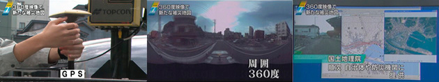
*Extracted images of “News 7”